
2025年7月4日 In this video, we dive into the fascinating world of GPS navigation. How does your phone or car know exactly where you are at all times? What’s the science behind it, and how did this technology come to be? From its military origins to its incredible modern-day uses, we’ll cover the history, the mechanics of satellites and triangulation, and how GPS has transformed the way we navigate the world.
Whether you’re curious about how GPS works or just want to learn more about this revolutionary gadget, this video is for you!
Timestamps:
0:16 – Introduction
1:05 – The Origins of GPS: A Military Invention
2:47 – How GPS Works: The Science Behind the System
4:25 – Triangulation: The Key to GPS Accuracy
5:43 – The Role of Time: Why Precision Matters
6:34 – The Evolution of GPS Technology
7:35 – The Future of GPS: Beyond Navigation
8:25 – Conclusion
#GPS #HowDoesGPSWork #GPSNavigation #Triangulation #Satellites #ScienceBehindGPS #HistoryOfGPS #Technology #GPSExplained #GlobalPositioningSystem #TechExplained #NavigationTechnology #SmartphoneGPS #GPSAccuracy #Geolocation
Prompt to Gemini:
Please give a comprehensive summary of the following YouTube, in 1000 words, formatted as a document:
https://youtu.be/PaxinQDZUVM?si=wCgEgvzadUBWrEgc
這部由「簡單事物歷史」(History of Simple Things) 頻道製作的影片《GPS導航是如何運作的?》,深入探討了全球定位系統(GPS)背後的迷人科學與歷史,這項技術如今已成為我們日常生活中不可或缺的一部分 [00:52]。
冷戰時期的起源
GPS的發展始於冷戰時期,當時美國軍方尋求一種可靠的導航系統,以供攜帶核飛彈的潛艇使用 [01:06]。在1950年代和1960年代,精確導航,尤其是在公海等偏遠地區,面臨著巨大的挑戰 [01:13]。美國海軍最初嘗試了一種名為Transit的系統,它利用衛星網路幫助潛艇確定位置 [0001:22]。儘管Transit並不完美,但它為最終演變為GPS的系統奠定了基礎 [01:31]。
導航星GPS的誕生
1973年,美國國防部啟動了導航星GPS計劃,其宏偉目標是創建一個能夠在地球上任何地點、任何時間、任何天氣條件下提供精確位置數據的系統 [01:44]。軍方有具體的要求:他們需要知道部隊、艦船和飛機的確切位置,並能精確引導飛彈 [02:02]。為此,需要一個圍繞地球軌道運行的衛星系統,不斷發射能被地面GPS接收器接收到的信號 [02:09]。
轉向民用
儘管GPS最初是為軍事應用而開發的,但美國政府在1980年代做出了一項關鍵決定,將其開放給民用 [02:22]。這項決定改變了遊戲規則,因為它突然讓任何擁有GPS接收器的人都能確定自己在世界任何地方的位置 [02:29]。這種可及性使得GPS技術迅速擴展到日常生活中 [02:37]。
GPS背後的科學:衛星、時間與三角測量
影片深入探討了GPS如何精確定位的核心科學,重點關注衛星、時間和三角測量 [02:48]。
衛星網路:GPS依賴於至少24顆衛星組成的網路,這些衛星分佈在地球軌道上,以確保在地球上任何一點都能同時看到至少四顆衛星 [03:00]。每顆衛星都配備了高度精確的原子鐘,確保所有衛星之間完美同步 [03:13]。這些衛星不斷發射信號,其中包括它們的精確位置和信號發送的確切時間 [03:22]。
信號接收與計算:當GPS設備(如手機、汽車導航或獨立接收器)啟動時,它會開始偵聽這些衛星的信號 [03:30]。設備會測量每個衛星信號到達接收器所需的時間,從而計算出與每個衛星的距離 [03:36]。
三角測量:計算出的距離隨後用於一種稱為三角測量的過程,以確定接收器的確切位置 [03:43]。這個過程被比作解謎,每顆衛星都提供一個關於接收器位置的線索,並且可用的線索(衛星)越多,位置就能越精確地確定 [03:50]。除了位置,GPS還能計算海拔、速度和行進方向,所有這些都歸功於精確的衛星信號和複雜的數學計算 [04:08]。
理解三角測量
影片透過一個比喻簡化了三角測量的概念 [04:26]。想像一下在公園裡,你試圖利用地標來找到自己的位置:
知道你離一棵樹500公尺,將你的位置範圍縮小到以樹為中心、半徑500公尺的圓圈 [04:34]。
如果再知道你離一張長凳也有400公尺,你就可以畫出第二個圓圈,這兩個圓圈的重疊部分將提供一個更精確的位置概念 [04:47]。
最後,如果知道你離一座雕像300公尺,就可以畫出第三個圓圈,而這三個圓圈的交點就能精確地確定你的位置 [05:02]。這基本上就是GPS三角測量的工作原理,只不過它使用的是來自太空衛星的信號,而不是公園地標 [05:09]。為了獲得最佳精度,GPS接收器需要來自至少四顆衛星的信號:前三顆確定經緯度,而第四顆則有助於確定海拔高度,這對於航空等應用至關重要 [05:17]。
計時與相對論的關鍵作用
計時是GPS最關鍵的方面之一 [05:44]。衛星上的原子鐘精確無比;即使是微小的時間差異也可能導致顯著的位置誤差 [05:49]。例如,僅僅一微秒(百萬分之一秒)的時間誤差就可能導致數百公尺的位置誤差 [05:59]。
此外,愛因斯坦的相對論也扮演著至關重要的角色 [06:05]。由於衛星高速運動且距離地球遙遠,時間對它們來說實際上比在地球上流逝得慢 [0006:11]。為了保持準確性,GPS系統必須進行調整以糾正這些相對論效應 [06:19]。如果沒有這些校正,GPS就不會像現在這樣精確 [06:26]。
演變與現代應用
當GPS首次向公眾開放時,它是一種奢侈品,主要用於汽車、船隻和徒步旅行等戶外活動的專用設備中 [06:34]。然而,隨著技術的進步,GPS接收器變得更小、更便宜、更普及 [06:42]。智慧型手機的出現是一個重要的轉折點,它讓幾乎每個人的口袋裡都有了一個GPS接收器,而Google地圖和Apple地圖等應用程式則徹底改變了導航 [06:50]。
如今,GPS的應用遠不止於簡單的導航 [07:09]。它對於以下方面至關重要:
精準農業:農民使用GPS引導的拖拉機進行高精度農作物種植 [07:15]。
物流:追蹤貨物和管理供應鏈 [07:23]。
航空:飛機導航 [07:23]。
健身追蹤:監測運動和路線 [07:23]。
尋寶遊戲(Geocaching):一種現代尋寶遊戲 [07:31]。
GPS技術的未來
GPS技術不斷發展,現代系統提供的精度遠高於其前身 [07:36]。研究人員正在不斷努力進一步提高精度 [07:45]。一個令人興奮的發展是GPS與慣性導航系統等其他導航技術的整合,以創建更可靠、更精確的定位 [07:49]。
未來,GPS預計將催生新的應用,包括:
擴增實境體驗:用數位資訊增強現實世界的視圖 [08:01]。
自動駕駛汽車:為自動駕駛汽車提供精確的位置數據 [08:01]。
無人機送貨:引導無人機進行包裹遞送 [08:01]。 隨著衛星變得更加先進,預計在天氣預報和災害救援等領域也將有所改進,GPS可以在受災地區協調救援工作 [08:11]。
結論
從其軍事起源到廣泛的民用,GPS已成為現代生活中不可或缺的一部分 [08:26]。其底層科學,包括衛星、精確計時和三角測量,在幕後無縫運作,實現了輕鬆導航 [08:34]。無論是尋找當地咖啡店還是引導飛機飛越全球,GPS都從根本上改變了我們在空間中移動的方式 [08:43]。影片鼓勵觀眾欣賞數十年來科學和工程的努力,這些努力使這款革命性設備成為可能,以及它將如何繼續塑造我們的未來 [08:57]。
The video, “How Does GPS Navigation Work?” by the “History of Simple Things” channel, explores the fascinating science and history behind the Global Positioning System (GPS), a technology that has become an integral part of daily life.
Origins in the Cold War
The journey of GPS began during the Cold War, when the United States military sought a dependable navigation system for submarines carrying nuclear missiles. In the 1950s and 1960s, accurate navigation, especially in remote areas like the open ocean, presented significant challenges. The U.S. Navy initially experimented with a system called Transit, which utilized a network of satellites to help submarines determine their location. Although not perfect, Transit laid the essential groundwork for what would eventually evolve into GPS.
The Birth of Navstar GPS
In 1973, the Department of Defense launched the Navstar GPS program with the ambitious goal of creating a system capable of providing precise location data anywhere on Earth, at any time, and under any weather conditions. The military had specific requirements: they needed to know the exact positions of troops, ships, and planes, and to guide missiles with pinpoint accuracy. To achieve this, a system of satellites orbiting Earth was required, constantly transmitting signals that could be picked up by GPS receivers on the ground.
Transition to Civilian Use
While GPS was initially developed for military applications, the U.S. government made a pivotal decision in the 1980s to make it available for civilian use. This decision was a “game-changer,” as it suddenly allowed anyone with a GPS receiver to determine their location anywhere in the world [0002:29]. This accessibility led to a rapid expansion of GPS technology into everyday life.
The Science Behind GPS: Satellites, Time, and Triangulation
The video delves into the core science of how GPS pinpoints location, focusing on satellites, time, and triangulation.
Satellite Network: GPS relies on a network of at least 24 satellites orbiting Earth, strategically spread to ensure that at least four satellites are visible from any point on the planet at any given time. Each satellite is equipped with a highly accurate atomic clock, ensuring perfect synchronization among all satellites. These satellites continuously transmit signals that include their precise location and the exact time the signal was sent.
Signal Reception and Calculation: When a GPS device (such as a phone, car unit, or standalone receiver) is activated, it begins listening for signals from these satellites. The device measures the time it takes for each satellite signal to reach the receiver, which allows it to calculate the distance to each satellite.
Triangulation: The calculated distances are then used in a process called triangulation to determine the exact location of the receiver. This process is likened to solving a puzzle where each satellite provides a clue about the receiver’s position, and the more clues (satellites) available, the more accurately the position can be pinpointed. Beyond just location, GPS can also calculate altitude, speed, and direction of travel, all made possible by precise satellite signals and complex mathematical computations.
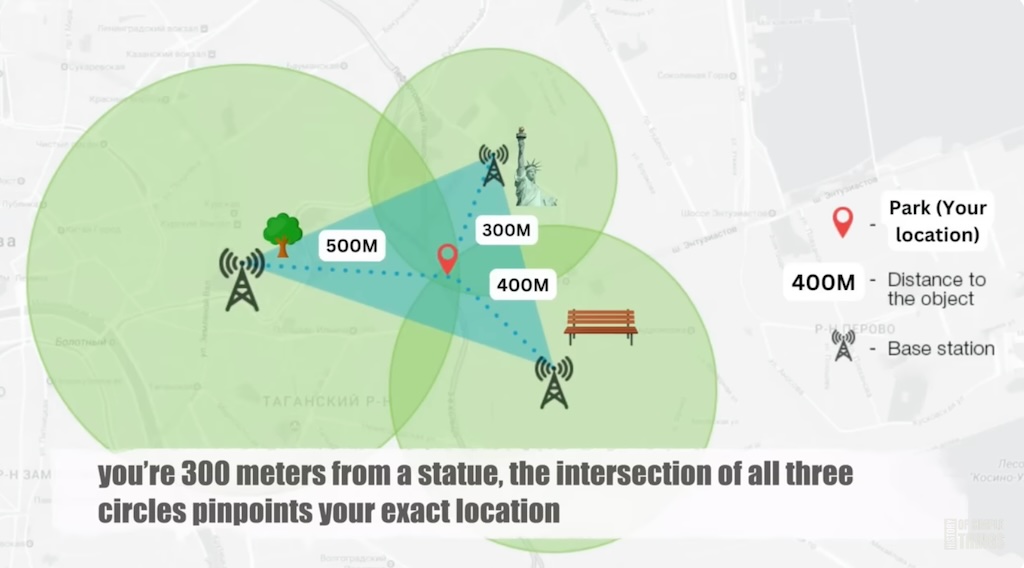
Understanding Triangulation
The video simplifies the concept of triangulation with an analogy. Imagine trying to find your location in a park using landmarks:
Knowing you are 500 meters from a tree narrows your location to a 500-meter radius circle around the tree.
Adding the information that you are also 400 meters from a bench allows you to draw a second circle, and the overlap of these two circles provides a more precise idea of your location.
Finally, knowing you are 300 meters from a statue allows for a third circle, and the intersection of all three circles pinpoints your exact location. This is essentially how GPS triangulation works, but instead of park landmarks, it uses signals from satellites in space. For optimal accuracy, a GPS receiver needs signals from at least four satellites: the first three determine latitude and longitude, while the fourth helps determine altitude, which is crucial for applications like aviation.
The Critical Role of Timing and Relativity
Timing is one of the most crucial aspects of GPS. The atomic clocks on the satellites are incredibly precise; even a minuscule time discrepancy can lead to significant errors in position. For example, a time error of just one microsecond (one-millionth of a second) could result in a location error of hundreds of meters.
Furthermore, Einstein’s theory of relativity plays a vital role. Because satellites move at high speeds and are far from Earth, time actually passes more slowly for them than it does on Earth. To maintain accuracy, the GPS system must make adjustments to correct for these relativistic effects. Without these corrections, GPS would not be nearly as accurate as it is.
Evolution and Modern Applications
When GPS first became publicly available, it was a luxury, primarily used in specialized devices for cars, boats, and outdoor activities like hiking. However, as the technology advanced, GPS receivers became smaller, more affordable, and widely accessible. The advent of smartphones was a major turning point, as it put a GPS receiver in nearly everyone’s pocket, and applications like Google Maps and Apple Maps revolutionized navigation.
Today, GPS extends far beyond simple navigation. It is essential for:
Precision Agriculture: Farmers use GPS-guided tractors for highly accurate crop planting.
Logistics: Tracking shipments and managing supply chains.
Aviation: Navigation for aircraft.
Fitness Tracking: Monitoring workouts and routes.
Geocaching: A modern-day treasure hunting game.
Future of GPS Technology
GPS technology continues to evolve, with modern systems offering far greater accuracy than their predecessors [0007:36]. Researchers are constantly working to improve precision even further. One exciting development is the integration of GPS with other navigation technologies, such as inertial navigation systems, to create even more reliable and accurate positioning.
In the future, GPS is expected to enable new applications, including:
Augmented Reality Experiences: Enhancing real-world views with digital information.
Self-Driving Cars: Providing precise location data for autonomous vehicles.
Drone Deliveries: Guiding drones for package delivery. As satellites become more advanced, improvements are anticipated in areas like weather forecasting and disaster relief, where GPS can coordinate rescue efforts in affected areas.
Conclusion
From its military origins to its widespread civilian use, GPS has become an indispensable part of modern life. The underlying science, involving satellites, precise timing, and triangulation, works seamlessly in the background, enabling effortless navigation. Whether used for finding a local coffee shop or guiding an aircraft across the globe, GPS has fundamentally transformed how we move through space. The video encourages viewers to appreciate the decades of scientific and engineering effort that made this revolutionary gadget possible and how it continues to shape our future.